Buffer strips along watercourses (GAEC 1)
This is an old version of the page
Date published: 12 August, 2015
Date superseded: 16 January, 2018
Buffer strips along watercourses
The aim of these rules is to protect water against pollution. The requirements restrict the storage, application of fertilisers and pesticides and cultivations along watercourses.
You must not:
1. apply organic manure* to any land which is situated within:
- 10 metres of any surface water*
- 50 metres of any well, borehole, etc for the supply of water
2. locate field heaps within:
- 10 metres of any surface water
- 50 metres of any well, borehole, etc, for the supply of water
3. apply chemical* fertiliser to any land in a way that makes it likely the fertiliser will directly enter any surface water
4. apply nitrogen fertiliser* to land if there is significant risk of nitrogen entering surface water, taking into account:
- the slope of the land, particularly if greater than 12 degrees
- any ground cover
- proximity to any surface water
- weather conditions
- the type of fertiliser being applied
5. cultivate land within two metres of the top of the bank* of surface water unless one of the following exemptions apply:
- cultivating to establish a green cover where one doesn’t already exist. A green cover excludes crops that are grown for a commercial purpose, for example arable crops including crops that are under sown with grass
- cultivating to establish a new hedge
6. apply pesticides within two metres of the top of the bank* of surface water unless the following exemption applies:
- spot applications of pesticides to control injurious weeds*, invasive species* and, after prior written consent of the Scottish Ministers and / or other statutory bodies, certain other weed species. If you are carrying out this exemption, please be aware of SEPA’s requirements for applying pesticides in or near water. Information on this can be found on the Application of Herbicide in or Near Water page of the SEARS website
Additional information
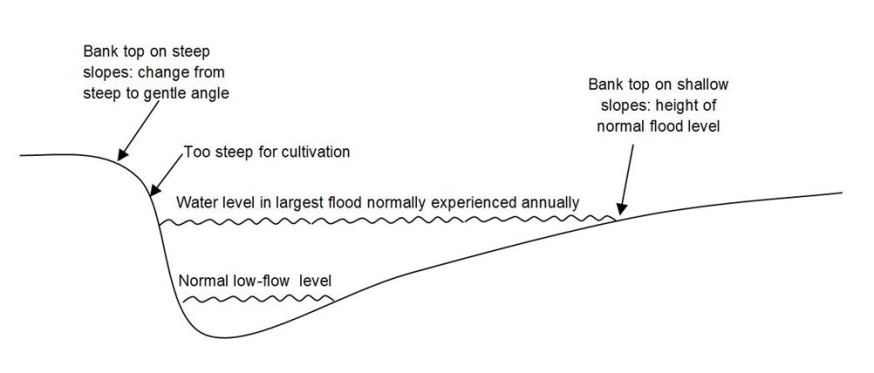
The location of the bank top depends on the bank profile and can be identified as follows:
1. Topping’ is permissible within the two meter buffer strip, however Greening rules may apply if this land is also part of your Ecological Focus Area (EFA). Further details on the greening requirements can be found here
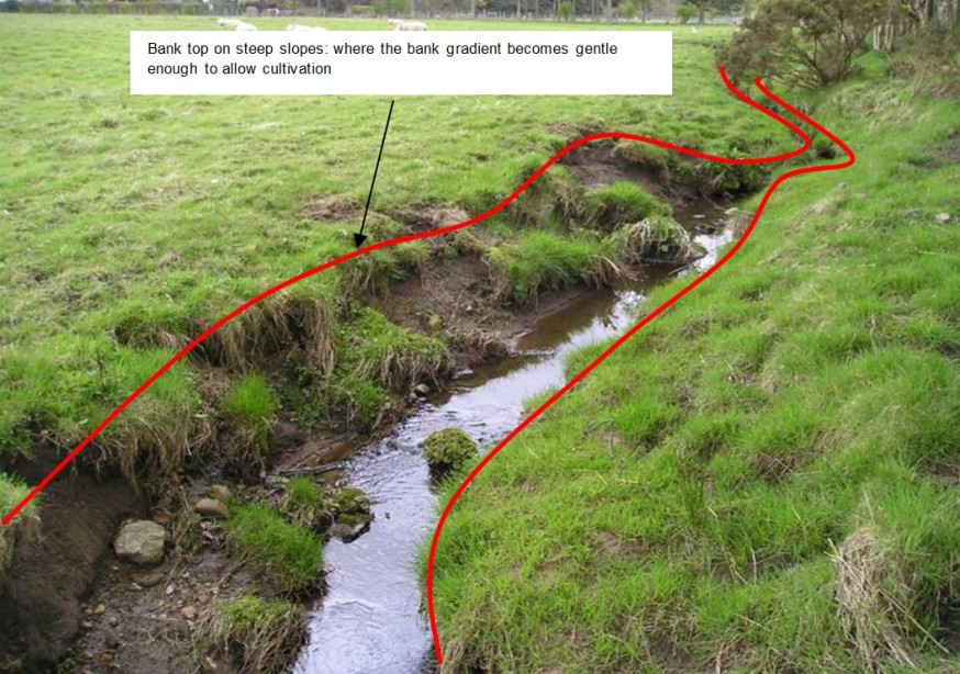
2. where the bank is fairly steep and an obvious bank face exists, the bank top is the highest part of the bank where the slope angle changes from steep to gentle and cultivation could take place (see below)

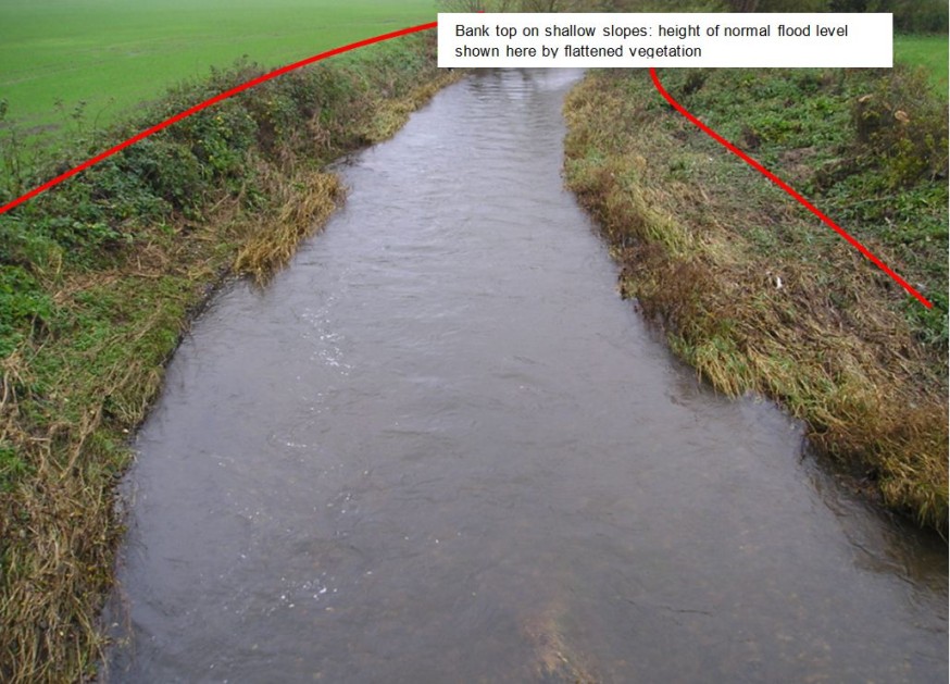
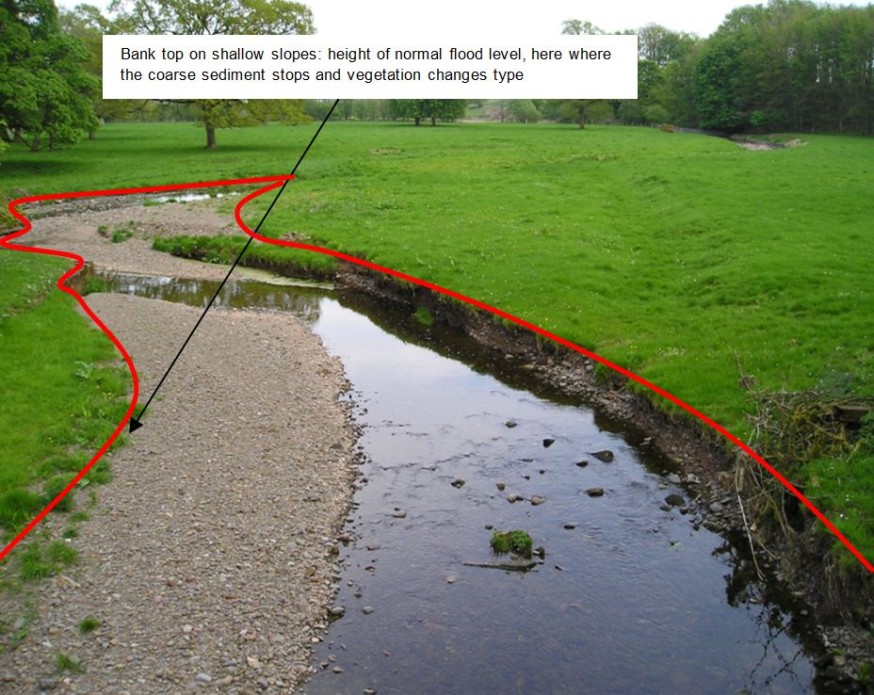
3. where the bank face is very shallow and there is no obvious break in slope, the bank top is the height to which water normally reaches during the largest flood normally experienced during the course of a year
Note, the flood height used here excludes the water height reached during rare major floods. The normal flood level height may be difficult to identify because there is not a single indicator that can be used to locate it.
Depending on the site, the following indicators may be used:
- traces left by high-water including flattened vegetation, deposited sediment (typically sands) or a high-water line of washed-up matter such as twigs or leaves
- exposed coarse sediments such as gravel
- changes in the pattern or type of vegetation


*Explanation of terms
'Organic manure' means livestock manure and nitrogen fertiliser derived from organic matter (sewage sludge, composted vegetable waste, etc).
'Surface water' include coastal water, lochs, rivers, burns, streams and ditches which contain free water and also temporarily dry ditches.
'Chemical fertiliser' means fertiliser which is manufactured by an industrial process.
'Nitrogen fertiliser' includes both organic manures and chemical fertilisers.
'Top of the bank' depends on the profile of the bank – see additional information images.
'Injurious weeds' are species specified in the Weeds Act 1959: Spear Thistle (Cirsium vulgare (Savi) Ten), Creeping or Field thistle (Cirsium arvense (L.) Scop.), Curled dock (Rumex crispus L.), Broad-leaved dock (Rumex obtusifolius L.) and Common Ragwort (Senecio jacobaea L.).
‘Invasive species’ means giant Hogweed (Heracleum mantegazzianum), Japanese knotweed (Fallopia japonica), Himalayan balsam (Impatiens glandulifera) and rhododendron (Rhododendron ponticum).
Previous versions
Download guidance
Click 'Download this page' to create a printable version of this guidance you can save or print out.
